The Mirror, Vol. 12, No. 567
Having just returned to Cambodia from Thailand after more than three weeks, I am still struggling to understand how differently the public is made aware and deals with critical issues. Though I had less direct access to the media in Cambodia, I feel at a loss to understand some elements of this difference.
One basic problem is the different level of easily available detailed documentation related to the case. As a result I saw during the past weeks – in the press, in mailing lists and on blogs from Cambodia many repetitive references to the 1962 decision of the International Court of Justice which “finds that the Temple of Preah Vihear is situated in territory under the sovereignty of Cambodia” – but this is broadly accepted, not contested in the Thai public. Newspapers, leaders of the government and of the opposition accept the 1962 International Court of Justice decisions that the Preah Vihear temple belongs to Cambodia.
But the often repeated insistence by Cambodian voices that “the case” is therefore settled, is only partly true. Is there a Khmer translation of the 1962 ruling on which the public discussion is based? (Access to its full official English text is referenced in the Mirror editorial of 29 June 2008).
In olden times, there were no clear national boundaries between Cambodia and Thailand. The governments of Siam and of France decided in 1893: “There shall be a delimitation of the frontiers between the Kingdom of Siam and the territories making up French Indo-China. This delimitation will be carried out by Mixed Commissions composed of officers appointed by the two contracting countries.” In 1904 it was again decided to do an unfulfilled task, as the International Court of Justice said with some surprise in 1962: “It seems clear … that a frontier was surveyed and fixed; but the question is what was that frontier (in particular in the region of Preah Vihear), by whom was it fixed, in what way, and upon whose instructions? The difficultly in answering these questions lies in the fact that, after the minutes of the meeting of the First Commission on 2 December 1906, there is no further reference whatever, in any minutes of later meetings, to the question of the frontier in the Dangrek region.”
Further negotiations happened, more maps were produced, but the Court said in 1962 also: “The Court will, for the moment, confine itself to … an argument which the Court considers to be correct, namely that the map was never formally approved by the first Mixed Commission as such, since that Commission had ceased to function some months before the production of the map… The Court must nevertheless conclude that, in its inception, and at the moment of its production, it had no binding character.”
Even after 1962 until today, the border between both countries has never been mutually agreed upon.
When the Court accepted in 1961 to take up the case, it said: “This is a dispute about territorial sovereignty.” The present Thai reservations are not about whether Preah Vihear belongs to Cambodia or not – it is about surrounding territories of about 4.6 square kilometer. Even one month before the present UNESCO meeting, there was no common position. And then quick acts followed each other:
22 May 2008: A 10 hours meeting between the Cambodian Deputy Prime Minister Sok An and the Thai Minister of Foreign Affairs Noppadon Pattama in Paris resulted in a renewed confirmation that Thailand supports Cambodia in registering the Preah Vihear temple as a World Heritage Site. The Cambodian side agreed to register only the Preah Vihear temple, leaving the disputed area unresolved – but a new map had to be prepared.
17 June 2008: The Thai government approves the new Cambodian map, without making the content of the Cambodian proposal public in Thailand – creating suspicion of some secret deals – though announcing that a disclosure of the content would happen “within days.” But it was already revealed that the new Cambodian map claimed only an area of about 20 to 30 meters around the temple. While it was not reported when the Cambodian government had made the decision about the new map, members of the Thai Senate questioned whether the Thai government had violated the Thai constitution by making an international agreement which affects Thai territorial sovereignty – for which the constitution prescribes a decision by parliament.
18 June 2008: Already on the following day, the ministers of the two countries who had conducted the negotiations, signed a Joint Communique at the UNESCO headquarters in Paris. The Joint Communique, reprinted in the press in Thailand, states: “The Kingdom of Cambodia strongly stresses that the inscription of the Temple of Preah Vihear is without prejudice to the demarcation work of the Cambodian-Thai Joint Commission on Demarcation for Land Boundary (JBC) between Cambodia and Thailand… The Kingdom of Cambodia accepts that the Temple of Preah Vihear be nominated for inscription on the World Heritage List without at this stage a buffer zone on the northern and western areas of the Temple.” And a map, signed by the head of the Cambodian Border Committee, explains the implications of these Cambodian decisions (see the map attached to the editorial on the Mirror of 29 June 2008).
29 June 2008: The Thai Administrative Court ruled that the government had overstepped its authority.
3 July 2008: The Thai Constitutional Court accepted, in response to requests by members of the Senate and by embers of the Parliament, also to initiate an investigation into the constitutionality of the government’s action – related to the implications for the territorial integrity of the country.
4 July 2008: The Thai Constitutional Court summoned the Thai Minister of Foreign Affairs to testify about his actions. The Thai government announced that they would, of course, abide by whatever their Constitutional Court decides.
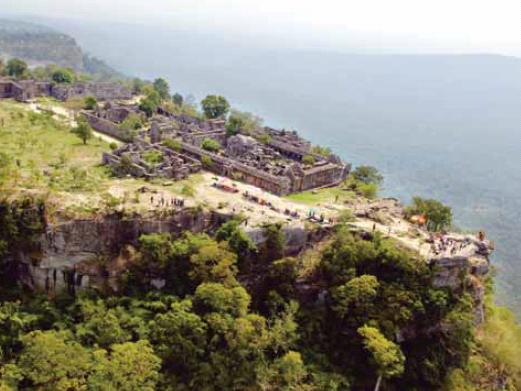
Preah Vihear
Preah Vihear – 500 meter above the lower plain (source: Cambodian submission)
What I could not answer, while still in Thailand and being asked:
How does the Cambodian public evaluate the geographical situation, that the Preah Vihear temple lies more that 500 meter above the Cambodian surroundings, and historically was built to be accessed only by pilgrims coming from the north, presently Thailand?
How might the Cambodian side intend to operate the Preah Vihear temple in its integrity, as a place of cultural and touristic pilgrimage, claiming only a 30 meter stretch of land around it? (What would practically happen, if there were only 30 meters uncontested territory around Angkor Wat as a tourism site?)
Why is the Preah Vihear historical heritage receiving such strong emotional response in the Cambodian public, while events related to other sites of its national history, like the privatization of the Killing Fields Memorial to a Japanese business company, did not lead to any public reaction?
How might the Cambodian public react, when organizations in neighboring countries would call on UNESCO to disregard whatever the Constitutional Council of Cambodia might decide?
Is there a danger that massive anti-Thai violence like in 2003 might erupt again, or is there a similar public critical appeals against irrational nationalism in Cambodia, as it is being voiced in the Thai public against Thai nationalism?

Nationalism leads to disaster
Nationalism (source: Bangkok Post)

Recent Comments